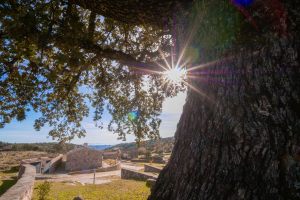
Do you practice hiking or would you like to engage in this activity? Explore the very essence of Montoro with a wide variety of hiking routes that you can check from the GPS of your Smartphone.
Hiking


nature and discover its landscape setting through its extensive municipal area.
Now we present you two blocks: on the one hand, there are hiking routes endorsed by the Region of Andalusia Mountaineering Federation and the Cordoba Provincial Government which are included in the NaturCOR Provincial Hiking Circuit. On the other hand, there is a route included in the GR-48 Senderos de Sierra Morena.
We also offer you some routes through the Sierra de Cardeña and Montoro Natural Park and its closest surroundings, known as preparque.
We recommend you to try the experience; it is perfect to have a different type of activity with family or friends and enjoy the benefits that hiking can give to you such as breathing clean and quality air. You can choose the one that best suits your preferences.
Naturcor
1st Route: Puerto Alto
Identification and location
- DEPARTURE: Fragua de la Encarna Roadhouse
- DESTINATION: Fragua de la Encarna Roudhouse
- ROUTE: Fragua de la Encarna Roudhouse – Roza Alta Route –
- Lagar de la Roza Alta – Membrillo Stream – GR 48 – Cordel de las Vacas Bravas –
- Corcome Stream – Corcome Route – Corcome Bridge – Zorra Route – Puerto Alto Mill – Hacienda de Ceniceros – Montoro- Empalme Path- Fragua de la Encarna Roadhouse
- HOW TO GET: Take the A-3102 toward Villa del Rio from the village of Montoro and turn left at 10.3 km toward Fragua de la Encarna Roadhouse. To enable the GPS navigation system: http://goo.gl/TgVBJ6
Descriptive data
- TYPE OF ROUTE: circular
- ROUTE LENGTH: 12.3 km
- ESTIMATED TIME: 3 hours and 45 min (with stops)
- LEVEL OF DIFFICULTY: Low-Medium
- DEPARTURE COORDINATES: 30S x= 384689 y= 4213477
- DESTINATION COORDINATE: 30S x= 384689 y= 4213477
- DEPARTURE ALTITUDE: 350 m
- DESTINATION ALTITUDE: 350 m
- MAXIMUM LEVEL: 455 m
- ASCENT LEVEL: 386 m
- DESCENT LEVEL: 392 m
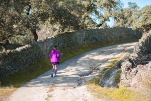
- TYPE OF PATH: 8% path, 67% sidewalk, 25% road.
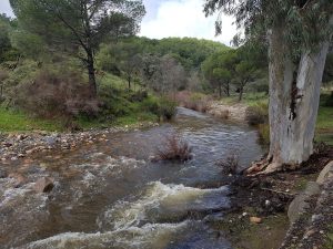
- GO THROUGH RIVERS/ STREAMS: Two streams – Membrillo Stream and Corcome Stream. If the flow is very large, there could be a problem to cross them.
- SHADES: Abundant in a 5%, Frequent in a 20%, limited in a 70% and Non-existent in a 5% of the route.
- WATER POINTS: There are no water points along the entire route.
Interesting resources
- ARCHAEOLOGICAL AND MONUMENTAL INTEREST: There are typical Andalusian wine lagares and farmhouses.
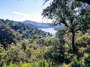
- LANDSCAPE INTEREST: The route offers you panoramic views of different types of landscapes. You can see the Guadalquivir valley in the south and different types of mountains of the Andalusian System in the background. You will have views of the southern part of Sierra Morena in the north, specifically views of the Sierra de Cardeña and Montoro Natural Park. Finally, you can appreciate extensive olive trees around you which dominate the area.
- GEOLOGICAL INTEREST: There are interesting mixed formations in the surroundings of Membrillos Stream.
- FLORA: The vegetation is dominated by the cultivation of olive trees, with small stamps of Mediterranean mountains where you will be able to see species such as the kermes oak, the holm oak, the jara pringosa, the rosemary, the asparagus or the labíernago. You can see another type of vegetation more associated with the watercourses (such as oleanders, tamujos or poplars) along the banks of the Corcome Stream.
- AVIFAUNA: You can see typical birds of agricultural environments (partridges, thrushes or nightjar) as well as yellow-winged ostriches, blackbirds, or warblers. The abundance of rabbits among the mammals stands out in the route and they can be seen in certain points of the route.
Other sidewalk data
- ENVIRONMENTAL RESTRICTIONS: No
- SIGNALLED SIDEWALK: Part of the route coincides with the GR-48.
- ACCESSIBILITY: way on foot (100%), bicycle route (95%), horse route (100%).
- CARTOGRAPHY: UTM-ED50. IGN 1:25.000. 903-IV San Julian Map.
- PARKING/PARKING AREA: Yes, it is near the departure.
- PUBLIC TRANSPORT: There is only to Montoro.
- TRACK AVAILABILITY: Yes
For more information and description of the route: See the route here (to add here the route PDF)
2nd ROUTE: "Pasá" Veguetas
Identification and location
- HOW TO GET: Take the CO-5101 road from Montoro “Plano de la feria” location. The departure of the route is located at 18 km. This route needs authorization to be trodden. Environmental education activities are allowed. The authorization must be submitted 15 days before doing the activity to the Environmental and Territorial Planning Delegation of Cordoba.
Interesting resources
– ARCHAEOLOGICAL AND MONUMENTAL INTEREST: There are typical Andalusian mills, lagares and farmhouses.
– LANDSCAPE INTEREST: The route offers you panoramic views of different types of landscapes. You can see the Guadalquivir valley in the south and different types of mountains of the Andalusian System in the background. You will have views of the southern part of Sierra Morena in the north, specifically views of Sierra de Cardeña and Montoro Natural Park and the Alcornocosas mountains. Finally, you can appreciate extensive olive trees around you which dominate the area.
– GEOLOGICAL INTEREST: The valleys are set deep in Sierra Morena, with steep slopes, where the olive trees of the mountain grow with a very pronounced erosion.
– FLORA: The vegetation is dominated by the cultivation of olive trees in the mountains and the typical Mediterranean vegetation, with specimens such as the holm oak, the kermes oak, the wild olive, the mastic, as well as scrub such as the rockrose, the heather, the rosemary, the broom or the cantueso.
– FAUNA: It is possible to see flocks of sheep, goats or pigs. You will be able to find the bastard snake and the largest of our snakes which is among the most outstanding reptiles: the ladder snake, as well as the long-tailed lizard and the lizard.
There is an abundance of avifauna, typical birds of the agricultural habitats for example, the quail, the turtle dove, the thrush and the wood pigeon, which are of interest to the small game hunting. Other species that you will find are the magpie, the starling, the robin, the hoopoe, the shrike, the oropendola and the nightingale. As for raptors the booted eagle and the owl must be highlighted. The mammals that forage in this area are: the wild cat, badgers, the genet, the fox, the dormouse and the field mouse. There are also species of hunting interest such as the wild boar, the deer, the rabbit or the hare.
3rd Route: Guadalquivir Meanders
Identification and location
- HOW TO GET: Take the A-4 Madrid – Cadiz toward Madrid from Cordoba and follow it until the 359 km. Once you are in Montoro you have to take the Avda. Andalucía to get to Plano de la Feria which is next to the bullring.
Interesting resources
– ARCHAEOLOGICAL AND MONUMENTAL INTEREST: There are the Puente Mayor, lagares, mills, water mills (of Roman and Muslim origin). There are different farmhouses.
– LANDSCAPE INTEREST: The route offers you different types of landscapes. You can see the Guadalquivir valley in the south with different mountain types of the Andalusian System in the background. There are panoramic views of the historical centre of Montoro with its hanging houses, El Retamar district and the Guadalquivir Meander (Natural Monument).
– GEOLOGICAL INTEREST: The valleys are set deep in Sierra Morena with steep slopes, where the olive trees of the mountain grow with a very pronounced erosion.
– FLORA: The vegetation is dominated by the cultivation of olive trees and the typical Mediterranean vegetation such as the holm oak, the kermes oak, the wild olive, the mastic, as well as scrub such as the rockrose, the heather, the rosemary, the broom or the cantueso. You will also find fig trees and walnut trees in the gardens. You will see riverside vegetation made up of poplars, tamujares, oleanders and tarajes, as well as ash trees in the side that runs next to the Guadalquivir river.
– FAUNA: There is a wide variety of fauna in this area. You can find the bastard snake and the largest of our snakes: the ladder snake, as well as the long-tailed lizard and the lizard among the reptiles.
There is an abundance of avifauna, typical birds of the agricultural environments such as, the quail, the common dove and the wood pigeon, and it is of small game interest; but also there are other species like the magpie, the starling, the robin, the hoopoe, the shrike, golden orioles and the nightingale. The booted eagle and the owl stand out among the raptors.
The mammals in this area are: the wild cat, badgers, the genet, the fox, the dormouse and the field mouse. It is also worth highlighting species of hunting interest such as the wild boar, the deer, the rabbit and the hare.
4th Route: Conejero
Identification and location
- HOW TO GET: Take the A-4 Madrid-Cadiz dual-carriageway toward Madrid to get to Montoro from Cordoba which you follow until the 359 km. Once you are in Montoro you should take Avda. Dr. Fleming to border the village and get to the Puente Mayor; from there, you access to the car parks next to Paseo del Brillante in Montoro.
Interesting resources:
– ARCHAEOLOGICAL AND MONUMENTAL INTEREST: There are the Puente Mayor, lagares, mills, water mills (of Roman and Muslim origin).
– LANDSCAPE INTEREST: The route offers you different types of landscapes. You can see the Guadalquivir valley in the South with different mountain types of the Andalusian System in the background. You will have panoramic views of the historical centre of Montoro with its hanging houses, El Retamar district and the Guadalquivir Meander (Natural Monument).
– GEOLOGICAL INTEREST: The valleys which are set deep in Sierra Morena have steep slopes, where the olive trees of the mountain grow with a very pronounced erosion.
– FLORA: The vegetation is dominated by the cultivation of olive trees and the typical Mediterranean vegetation such as the holm oak, the kermes oak, the wild olive, the mastic, as well as scrub such as the rockrose, the heather, the rosemary, the broom or the cantueso. You will see fig trees and walnut trees in the gardens. You will find riverside vegetation made up of poplars, tamujares, oleanders and tarajes, as well as ash trees in the side that runs next to the Guadalquivir river.
– FAUNA: The fauna that is developed in this area is quite varied. There are different species which are distributed in different places in the territory of Montoro. Thus, it is possible to see flocks of sheep, goats, or pigs in wooded, meadows and olive trees areas.
There is an abundance of avifauna, typical birds of the agricultural environments such as, the quail, the common dove and the wood pigeon, and it is of small game interest; but also, other species like the magpie, the starling, the robin, the hoopoe, the shrike, golden orioles and the nightingale. The booted eagle and the owl stand out among the raptors.
The mammals in this area are: the wild cat, badgers, the genet, the fox, the dormouse and the field mouse. It is also worth highlighting species of hunting interest such as the wild boar, the deer, the rabbit and the hare.
You can find the bastard snake and the largest of our snakes: the ladder snake, as well as the long-tailed lizard and the lizard among the most outstanding reptiles.
5th Route: Conglomerados
Identification and location
- HOW TO GET: Take the A-4 Madrid-Cadiz dual- carriageway toward Madrid to get to Montoro from Cordoba and follow it until the 359 km. Once you are in Montoro, take Avda. de Andalucía to get to the Plano de la Feria which is next to the bullring.
Interesting resources:
– ARCHAEOLOGICAL AND MONUMENTAL INTEREST: There are the Puente Mayor, lagares, mills, water mills (of Roman and Muslim origin). There is a stone-paved path preserved by stretches in the Palmilla mountain range.
– LANDSCAPE INTEREST: The route offers you different types of landscapes. You can see the Guadalquivir valley in the south with different mountain ranges of the Bético System in the background. You can have panoramic views of the historical centre of Montoro with its hanging houses, El Retamar district and the Guadalquivir Meander (Natural Monument).
– GEOLOGICAL INTEREST: The valleys of Sierra Morena, with steep slopes in which olive trees grow in the mountain with a very pronounced erosion. Conglomerados del Bunter.
– FLORA: The vegetation is dominated by the cultivation of mountain olive groves and typical Mediterranean vegetation, with specimens the holm oak, the kermes oak, the wild olive, the mastic, as well as scrub such as the rockrose, the heather, the rosemary, the broom or the cantueso. You ca see fig trees and walnut trees in the gardens. You will find riverside vegetation made up of Choperas, poplars, tamujares, oleanders and tarajes, as well as ash trees in side that runs next to the Guadalquivir river.
– FAUNA: The fauna that is developed in the area is quite varied. It is possible to see flocks of sheep, goats or pigs.
There is abundance of avifauna, typical birds of the agricultural means for example, the quail, the common dove, the thrush and the wood pigeon. As for raptors, the booted eagle and the owl are worth mentioning.
The mammals that look for food or are housed in this area are: the wild cat, badgers, the genet, the fox, the dormouse and the field mouse. Besides, some species of interest include the wild boar, the deer, the rabbit and the hare. Among the most outstanding reptiles you can find the bastard snake and the largest of our snakes: the ladder snake, as well as the long-tailed lizard and the lizard.
6th: Via Augusta
Identification and location
- HOW TO GET: Take the A-4 Madrid-Cadiz dual- carriageway toward Madrid and follow it until 359 km to get to Montoro from Cordoba. Once you are in Montoro, take Avda. Andalucia to get to Plano de la feria which is next to the bullring of Montoro.
Main resources
– ARCHAEOLOGICAL AND MONUMENTAL INTEREST: There are the Puente Mayor, lagares, mills and water mills (of Roman origin).
– LANDSCAPE INTEREST: The route offers you different types of landscapes. You can see the Guadalquivir valley in the south with different mountain ranges of the Bético System in the background. There are panoramic views of the historical centre of Montoro with its hanging houses, El Retamar district and the Guadalquivir Meander (Natural Monument).
– GEOLOGICAL INTEREST: The valleys of Sierra Morena, with steep slopes in which olive trees grow in the mountain with a very pronounced erosion.
SIERRA DE CARDEÑA Y MONTORO PARK
The natural Park offers you a complete path network suitable for walking, cycling and horse or donkey riding. You will be able to see herds of pigs in the meadows and even some cows pasturing freely, you will be able to see many stags and boars depending on the season and time.
PREPARQUE
Do you feel like practising hiking in the surroundings of the Natural Park? We offer you three different routes where nature and disconnection go together and you can enjoy with your family and friends.
1st Route - Between olive groves and streams: El Madroñal
Route data
Route length: 7 km
Estimated time: 2 hours
Level of difficulty: Low-Medium
Type of route: Circular
How to get?
Take the exit 58 from Montoro taking the N-420 road toward Cardeña. At the intersection, turn right to access the service road of this same road, returning to Montoro. You will find the start of the trail on the left after about 200 metres.
Description
This route takes its name due to the Pago de El Madroñal. The route begins surrounded by olive trees with Mediterranean mountain vegetation (holm oaks, kermes oaks, rockroses, cantuesos and so on.). You will be able to see the Mojapiés farmhouse 300 metres away from the start. This construction was an old oil mill.
The route descends down Mojapiés stream, which is characterized by riverside vegetation such as brambles, tamujos, oleanders and myrtles, among other species.
At the lowest point of the route (about 4 km) we find the mouth of this stream at Martin Gonzalo, where also Gamonosas stream flows its waters.
The route ascends along the Granadal path from this point, and it is enclosed in its final section by stone walls or “fences” that delimit the olive groves properties of the mountains on both sides.
When you reach the service road again, turn right and walk about 600 metres to reach the starting point, where the route ends.
2nd Route - The Mediterranean Forest: Pizarranga
How to get?
Take the N-420 road toward Cardeña and take the exit 54 at 7 km from Montoro and join to the CO-5101 road. This route starts around 3 km of this road, just crossing the bridge over the Arenosillo stream, if you follow a path on the right.
Description
The Pizarranga path initially runs along the right bank of Arenosillo stream, through an olive grove landscape full of holm oaks.
Little by little, the typical vegetation of the Mediterranean forest becomes clearer as the route moves away from the surroundings of the reservoir, appearing lentiscos, kermes oaks, labiérnagos, some gorses and cornicabras.
Approximately 1.4 km from the start, you will be able to locate the Pizarranga Farmhouse, which is located on the right side of the route. The route goes into an alley full of natural vegetation which houses and gives food to coalfishes, robins and warblers, among other birds.
Next, a meadow of holm oaks makes its way to the left, while on the other side, traditional mountain olive trees dominate the landscape. The path ends arriving at CO-5101 road around 10 km.
3rd Route - Descending to the Arenoso: La Cebadilla
How to get?
Take the exit 54 and join to CO-5101 road of the N-420 road toward Cardeña from Montoro. The route starts at 10.2 km of this road on the left and its departure is about 30 metres away of the end of Pizarranga path.
Description
The route of La Cebadilla begins next to forest lands full of Mediterranean vegetation, which enhances the presence of big game species (deer, mouflon and wild boar).
About 400 metres from the start, the foothills of Sierra Morena can be seen on the right: steep hills such as La Chaparrera, La Encinilla and El Alcornocal.
You will be able to see the valley that comes from the Valdediego stream, Las Piedras de la Sal, La Loma de la Higuera and Cebrián at 1,7 km away if you stand in front of this mountain range, in which there are abundant reforested pine trees together with oaks and cork oaks; there are olive groves in the mountains on the left, from which olive oil rich in polyphenols and antioxidants is obtained and protected by Montoro-Adamuz Protected Designation of Origin.
Then continue down on the path toward the Arenoso reservoir and follow it along its banks, surrounded by pine trees and Mediterranean scrub.


